Data news: "Super Violent Plum" ended and set a number of records.
China Meteorological News reporter Cui Guohui
Expert consultant of this paper: Zhou Bing, Chief of Climate Service Office of National Climate Center.
Wei li, Deputy Director of Climate Service Office of National Climate Center.
Cui Tong, Assistant Research Fellow, Climate Service Office, National Climate Center
Liang Xudong, Director of State Key Laboratory of Disaster Weather, China Academy of Meteorological Sciences
On August 2nd, the 62-day "super-long" Meiyu finally ended. This year’s plum rainy season not only lasted for a long time, but also accumulated the most rainfall since 1961, which was called "super violent plum" by netizens.
How "violent" is this year’s Meiyu? What are the reasons for the long duration and large amount of plum rain? Meteorologists gave an analysis.
How strong is the plum rain this year?
According to the monitoring results of Meiyu in National Climate Center and referring to the national standard of Meiyu Monitoring Index (GB/T 33671-2017), the regional climate division of Meiyu monitoring in Jianghuai Basin in China is divided into three parts: Jiangnan District (Area I), Middle and Lower Reaches of the Yangtze River (Area II) and Jianghuai District (Area III).
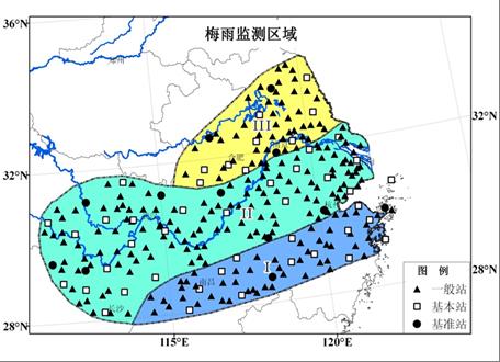
Three main Meiyu monitoring areas defined by the national standard of Meiyu Image source: National Climate Center.
The overall climate characteristics of Meiyu period in 2020 are as follows: the time of entering Meiyu is early, the time of leaving Meiyu is late, the duration of Meiyu period is long, the amount of Meiyu is large, and extreme precipitation events occur frequently.
How violent is Meiyu this year?
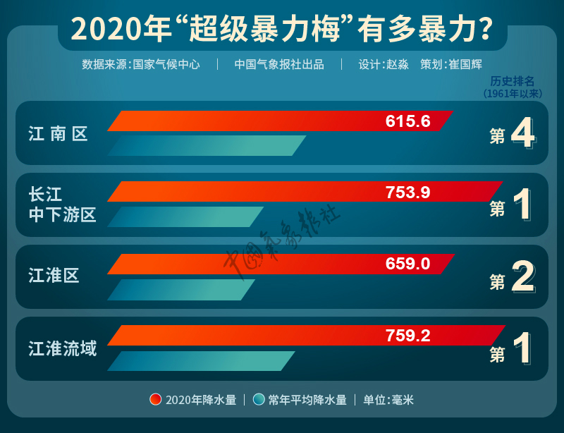
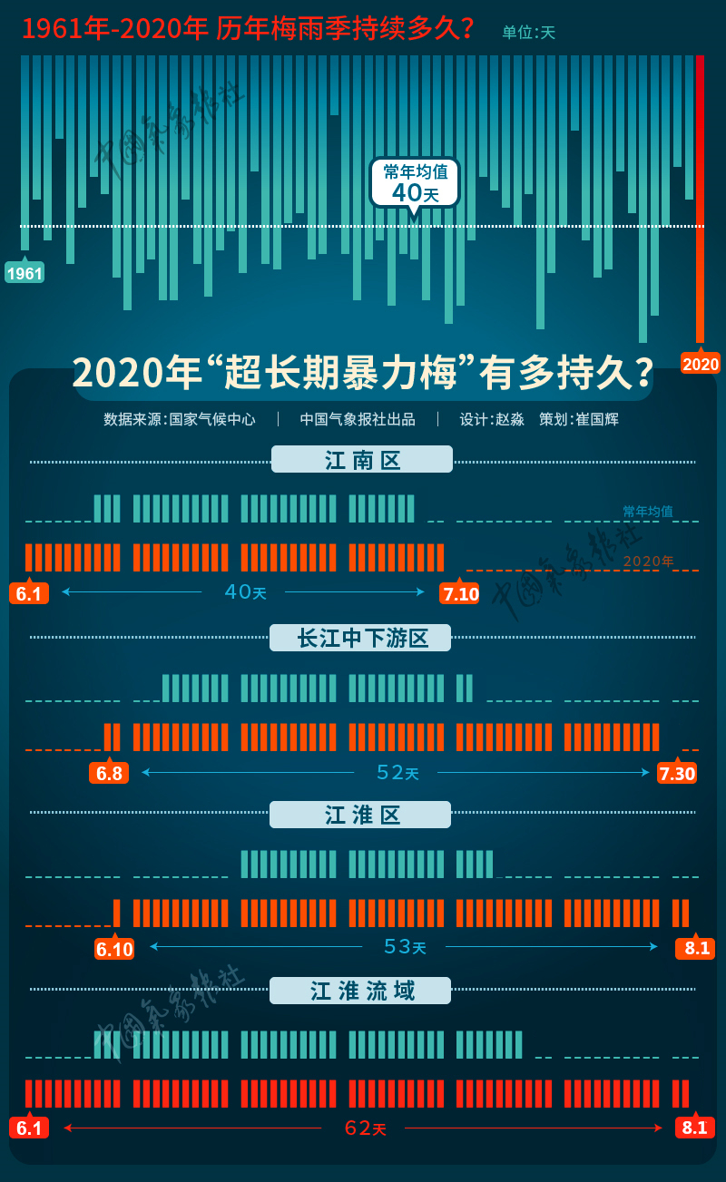
The precipitation in the rainy season in the Jianghuai basin is 759.2 mm, which is second only to 789.3 mm in 1954, 1.2 times more than normal, and the highest in history since 1961. At the same time, the rainy season lasts for 62 days, 22 days longer than normal, and ranks as the longest since 1961 with 2015.
The daily precipitation in 46 cities (counties) reached the standard of extreme events, and the daily precipitation in Jinzhai, Anhui (309.5mm, July 18th), Lu ‘an (290mm, July 18th), Tongling (209.1mm, July 6th) and Xinjian, Jiangxi (220mm, July 8th) broke the historical record. The number of continuous precipitation days in 33 cities (counties) reached the standard of extreme events, and the number of extreme continuous precipitation days in 10 stations such as Hefei, Anhui (21 days) and Anyi, Jiangxi (25 days) broke the historical record.
How long will the plum rains last this year?
Among them, Jiangnan District entered Mei on June 1, 7 days earlier than normal, and Mei on July 11, 3 days later than normal; The length of Meiyu period is 40 days, which is 10 days longer than normal. The average rainfall in Meiyu area reached 615.6 mm, 68.5% more than normal.
The middle and lower reaches of the Yangtze River entered Mei on June 9, five days earlier than normal, and on July 31, Mei was 18 days later than normal. The length of Meiyu period is 52 days, which is 23 days longer than normal. The average rainfall in Meiyu area is 753.9 mm, 168.3% more than normal, the highest since 1961.
Jianghuai District entered Mei on June 10th, 11 days earlier than normal, and 18 days later than normal on August 2nd. The length of Meiyu period is 53 days, which is 28 days longer than normal. The average rainfall in Meiyu area is 659.0mm, which is 149.2% more than normal, the second time since 1961.
What is the cause of persistent heavy precipitation?
According to the analysis of the National Climate Center, there are four main reasons for the persistent heavy precipitation in the Meiyu season in the Jianghuai Basin this year:
First, the meiyu season in the Jianghuai Basin generally starts early, and the meiyu period is long. The cold and warm air is evenly matched around the middle and lower reaches of the Yangtze River, and the meiyu front system is active, which is the direct reason for the unusually high amount of meiyu.
Second, the western Pacific subtropical high (subtropical high) system continues to be abnormal for a long time. In the first half of June, the ridge line of subtropical high is located to the north; From late June to July, it has been southerly, which is conducive to the convergence of cold and warm air in the Jianghuai basin, forming a number of large-scale rainstorm processes.
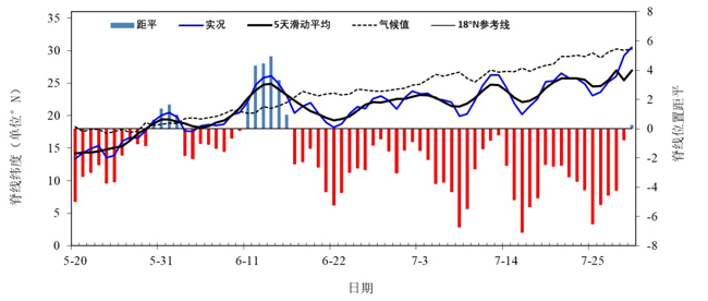
Daily variation of the ridge position of the western Pacific subtropical high since late May Image source: National Climate Center.
Third, the meridional circulation in the middle and high latitudes develops and the cold vortex is active; The warm and humid air currents from the South China Sea and the western Pacific Ocean are strong, and the water vapor transport in Meiyu area mainly comes from the contribution of subtropical high from southeast air currents to southwest air currents near the western ridge.
Fourth, the weak "El Nino event" that ended in the early spring and the unusually warm SST in the equatorial Indian Ocean resulted in a significantly stronger subtropical high. The atmospheric external forcing effect of SST anomaly in the North Indian Ocean on the subtropical high in July.
It is reported that the years in history when the rainy season lasted for a long time and the rainy season was heavy were: 1954, 1969, 1983, 1998 and 2016, among which the last three years were related to three super El Ni? o events in 1982/1983, 1997/1998 and 2015/2016 respectively.
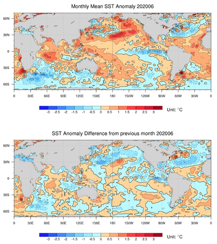
June 2020 global sea surface temperature anomaly (top) and monthly sea surface temperature range (bottom) Image source: National Climate Center.
According to Liang Xudong, director of the State Key Laboratory of Disaster Weather of China Academy of Meteorological Sciences, in addition to the long-term convergence of tropical warm and humid airflow in the middle and lower reaches of the Yangtze River and the cooperation of cold air in the middle and high latitudes, the abnormal warming in the Arctic and the excessive snow in the early stage of the Qinghai-Tibet Plateau are likely to be the important factors causing the abnormal precipitation in the Yangtze River basin this summer.
According to the latest research, this year’s abnormal warming in the Arctic caused the abnormal meridional circulation in Europe and Asia through the effect on the weather system at middle and high latitudes, thus enhancing the southward transport of dry and cold air. This continuous transport of dry and cold air and the warm and humid air flow brought by subtropical high confronted each other for a long time in the middle and lower reaches of the Yangtze River, resulting in a continuous heavy precipitation process.
On the other hand, the excessive snow on the Qinghai-Tibet Plateau in the early stage caused the weakening of the atmospheric heating intensity on the plateau in summer. By adjusting the atmospheric circulation in East Asia, it is beneficial to strengthen the westward extension of the western Pacific subtropical high and to transport warm and humid air to the middle and lower reaches of the Yangtze River, causing abnormal precipitation. At present, further research is still in progress.
(Editor: Su Yujun)